


Book Tickets Online
About
Please Note: Section 4 of this walk is closed while an alternative route is being developed.
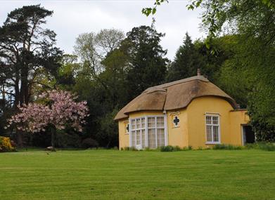
This circular route follows off-road trails, quiet country lanes and forest tracks from Newry around the volcanic landscape of the Ring of Gullion AONB. Along its route, ancient monuments and quiet villages can be discovered. The final section leads through the grounds of Derrymore House (owned and managed by the National Trust) near Bessbrook before reaching Newry.
Start Point:
J084257
Finish Point:
J074295
Route:
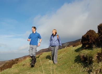
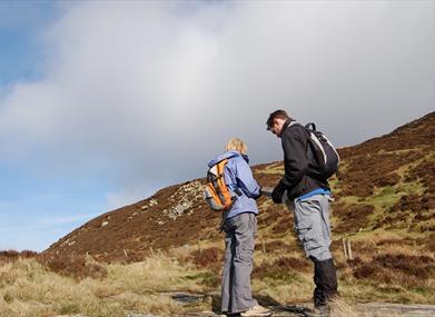
The Slieve Gullion ring dyke has long been celebrated by geologists, and this two-day walking route allows you to explore the area's unique natural history by foot. The route follows a mixture of footpaths and country lanes as it makes its way around the ring, passing numerous historical sites along the way.
Section 1 Newry to Flagstaff (8.1km)
The route begins by heading out of Newry and traversing the slopes of Fathom Mountain, the first hill encountered on the ring dyke. From the bridge over Newry Canal, cross the road towards The Quays shopping centre. Head southwest along the road signed to Dublin and the A1. Follow the pavement beside the road, climbing gradually for 2km. Just before the railway bridge, turn left onto Flagstaff Road. Ahead there are views to Fathom Mountain, your next destination. Take the next lane on the right and continue past an old farm building, then turn left onto a ‘green road’. This starts as a muddy track, then turns into a grassy footpath that weaves between the fields. Continue along the path beside the railway and after you reach a tarmac road, walk along it and cross the railway bridge to join the main road. Head left here for 300m, then turn left again onto a narrow lane signed as Upper Fathom Road.
Climb gently along the road, passing round the side of Fathom Mountain and enjoying good views west over the rolling countryside. After 2.5km the route switches to the eastern side of the mountain, allowing a different panorama to unfold. Beyond Carlingford Lough the clustered peaks of the Mourne Mountains decorate the skyline, with some of the highest summits in Northern Ireland on show. Continue to a T-junction at Flagstaff, which marks the end of the section. Did You Know? Formed some 60 million years ago, the Slieve Gullion ring dyke was created by a massive volcanic explosion. The eruption obliterated the central volcano, but left a circle of hills radiating around the main caldera. The formation measures some 150km² and is considered the finest example of its type in Britain and Ireland.
Section 2 Flagstaff to Marble Bridge (10.4km)
You now climb the slopes of Black Mountain, the second highest peak of the ring dyke. Turn right at Flagstaff T-Junction and continue for 1km to a narrow lane on the left, signed to Clontygora Court Grave. This neolithic tomb is located close to the bottom of the lane, and is well worth a visit. From here, continue uphill along the lane, climbing between high stone walls. The route takes you on a loop past numerous small farms before descending back to the larger road. Turn left here, then left again some 500m later. This road climbs to the summit of 508m-high Black Mountain, and though you won’t be going all the way to the top, you will be gaining over 200m in altitude over the next 3km.
The climb is sustained at first then eases slightly, with the surrounding peat moorland becoming wilder as you progress. After 3km, the route turns right, past a metal gate and onto a gravel track. You are now within the boundary of Ravensdale Forest. Continue straight ahead at the first track junction, ignoring the left-pointing yellow Tain Trail waymarker and descend into the trees, with great views where there are gaps in the vegetation. Keep left at the next junction, some 700m further, then after another 400m veer left again onto a smaller track.
Descend steeply now through the trees, and where the track bends right, look out for a narrow footpath heading off to the left. This muddy trail weaves between the trunks, bringing you to a fantastic section high above a stream gorge. Keep the stream gorge on your left and at a junction of trails turn right and after about 150m, turn left and descend a set of steps which lead on to a delightful walk by the bank of the stream and Marble Bridge car park Did You Know? Clontygora Court Grave, which is visited on this section, is a fine example of a neolithic tomb. You can still see the massive boulders that once formed the entrance to a more extensive structure, used by an early farming community for collective burial. The site has been dated to between 4000 and 2500 BC.
Section 3 Marble Bridge to Forkill (15.7km)
A mixture of country roads and footpaths carry you to the village of Forkhill. From Marble Bridge car park, turn right and follow the road for 2km. Another right turn brings you to a roundabout, where you should head left, over the motorway towards Jonesborough. In Jonesborough village, follow the main road until you reach Kilnasaggart Road. Turn left down Kilnasaggart Road which soon narrows to a slim strip of tarmac sandwiched between high hedges. Descend to the bottom of a hill and pass under a railway bridge and up a short hill to a junction. Moyry Castle is a short detour to the left here, though the main route climbs to the right.
After 300m, turn right on reaching a road junction and carry on mainly downhill for 850m before turning left onto Carewamean Road which climbs over the shoulder of Slievenabolea giving superb views of Slieve Gullion and beyond. Descend the other side, then look out for a stile at the edge of a forest on the right, just before a sharp left turn. Cross the stile and follow a footpath into the forest, where the moss-cloaked understory creates a primeval atmosphere. Keeping the intermittent stone wall on your left, follow the often indistinct pathway for about 1km until you reach a stile. Cross the stile and negotiate a corridor of gorse for about 750m before crossing a stile and taking a left turn before descending along the forest boundary. Cross another stile, turn right and proceed for about 750m along a grassy track before reaching a metal gate which leads onto the tarmac. Turn left here and carry straight on for 1.3km. Turn right on reaching a T-junction and keep on this road (Captain’s Road, although it is not named at this junction) for 2km until reaching another T-junction.
Turn right onto a busy road for about 250m before veering left down a track. After about 500m, turn right at a T-junction, then look out for a wooden gate on the left. You now pass around several fields to reach the Kilcurry River, which is crossed via a metal footbridge. Turn right on the opposite bank, then veer left between fields. The path turns into a track and brings you to a road at the edge of Forkhill. Turn right and continue through the centre of the village, then turn right again to reach the B134 road. Did You Know? Just south of Jonesborough the route passes a mountain saddle known as Moyry Pass, or the 'Gap of the North'. This was once a major thoroughfare between the provinces of Ulster and Leinster. The pass is guarded by Moyry Castle, which was built in 1601, and can be visited in a short detour from the route. Section 4 Forkill to Slieve Gullion Courtyard Centre (9.3km) (Please note this section of the Ring of Gullion Way is closed while an alternative route is being developed) Did You Know? On Slieve Gullion's summit plateau lies Calliagh Berra's Lough. The pool is named after a woman famed in local folklore for bewitching the giant Finn McCool. She tricked him into diving into the lough, and when he surfaced his hair had turned completely white. Legend has it that the same fate will befall any person who swims in the waters today.
Slieve Gullion - Alternate Route (7.4km)
This alternate mountain loop passes over Slieve Gullion summit, and is recommended for experienced walkers in clear weather. When you reach Slieve Gullion upper driveway, turn left and continue to a car park. Fifty metres later, the mountain path leads off to the right. This soon consolidates into an obvious, well-trodden trail marked by wooden posts. Climb past a stone shelter to arrive at the large cairn that marks the southern summit. This is actually a neolithic burial chamber, and the highest remaining passage tomb in Ireland. The trig point provides fantastic 360° views, which include the Mourne Mountains and Carlingford Lough. Now follow the path northwest across the summit plateau. Pass Calliagh Berra's Lough, then continue to the sprawling pile of stone that marks the northern summit. This cairn dates from the Bronze Age, around 1800BC. The descent path leads down to the north. At a grassy hollow, veer right and join a green track, then pass through two gates to reach a road. Turn right here, then right again at the next junction to rejoin the official route beside Killevy Old Church.
Section 5 Slieve Gullion Courtyard Centre to Camlough Forest (6km)
Country lanes carry you on towards Camlough Mountain. From the Courtyard Centre, descend along the exit driveway to reach a country road. Turn right here, then turn left at the next crossroads. Follow this road for roughly 2.5km, enjoying good views ahead to Camlough Mountain. Turn right opposite Killevy Old Church and begin to descend. Now take the third road on the left. Climb steadily along this narrow lane, then turn right at a T-junction. Continue for 1km to reach the metal entry gate for Camlough Forest. Did You Know? Killevy Old Church is located on the site of a former convent, founded by St Monnina in the 5th century. At the time this was one of the most important monastic sites in Ireland. The adjacent holy well is situated at the top of a boreen beside the church, and can be visited in a 1km detour from the route.
Section 6 Camlough Forest to Newry (11.4km)
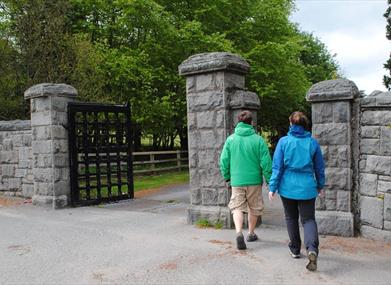
A long descent from Camlough Mountain leads to a memorable final section beneath Craigmore Viaduct. From the southern entrance to Camlough Forest, follow the old forest drive into the trees and begin to zig-zag up the mountain. Where the slopes are open near the top of the mountain, there are fine views over Newry and the ring dyke. Descend the northern slopes, then continue ahead along a narrow lane. There is now a good view over the numerous stone arches of the Craigmore Viaduct, your final goal of the route. Turn left at a T-junction, then right down Limekiln Road. This brings you to the A25 road on the outskirts of Newry. Turn left, then quickly right to enter the grounds of Derrymore House, an eighteenth century, cottage-style house and demesne now owned by the National Trust. Head along the driveway towards the yellow, thatched cottage. Where the road turns left, continue ahead along a track. Pass between grassy pastures, then through the beautiful planted woodland of the estate grounds. Now join a road and turn right. Please note there is a diversion in place until further notice, between the Derrymore Road and Millvale Road - walkers should continue along the Derrymore Road after exiting the grounds of Derrymore House, until meeting Millvale Park on the left. Follow Millvale Park to its end, before turning right to rejoin the route on the Millvale Road.
Turn left onto a cycleway and footpath. This continues alongside Bessbrook River, soon passing beneath the towering Craigmore Viaduct. Now turn right onto a lane, which brings you to the main A1 road. Turn right here, taking great care because traffic travels very quickly along the highway. After 600m, turn right to reach Newry train station, the official end point of the route. Did You Know? Craigmore Viaduct is a piece of Northern Irish engineering history. It was completed in 1852 to allow trains on the Dublin-Belfast line to span the Camlough River valley. It is around 400m long, and boasts 18 separate arches. The tallest arch is 38m high, making this the highest viaduct in Ireland.
Distance:
36 miles
Terrain:
Tarmac, off road tracks, forests
Point of interest:
Archaeological monuments, mountain views, scenic countryside
Facilities:
Refreshments, shops, car parks and toilets at the start in Newry and in Jonesborough, Forkill, Slieve Gullion Forest Park and Camlough.
Publication:
Ring of Gullion Waymarked Way Guide.
Publication availability:
Contact Newry Tourist Information Centre 028 3031 3170. Alternatively, the Guide is available to download on this webpage.
Nearest town:
Newry City
OS map:
Sheet 29
Accessible toilet facilities:
Yes
Accessible terrain:
Tarmac roads and off road paths, uneven and rough in places
Facilities
Provider Preferences
- Free (parking charges may apply)


