


Book Tickets Online
About
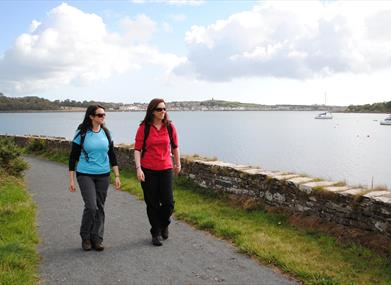
Lecale Way extends from the heart of Downpatrick, taking in Strangford Lough and finishing in the seaside resort of Newcastle. Tower houses, castles and ancient monuments are dotted throughout its landscape and a wealth of wildlife can be discovered along the contrasting shores of Strangford Lough and the Irish Sea. An entrance fee to Castle Ward applies (National Trust Property).Please note there will be a temporary closure of the Lecale Way between Auldleystown Rd. and the Caravan Park all day on Synday 16th September to facilitate the National Trust's Winterfell Festival.
Start Point:
J485445
Finish Point:
J376310
Route:
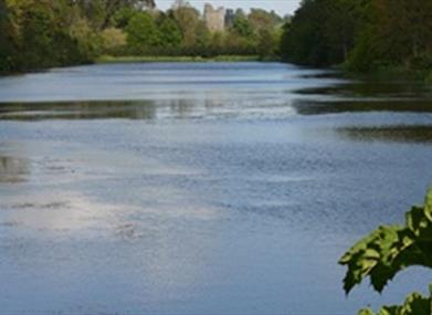
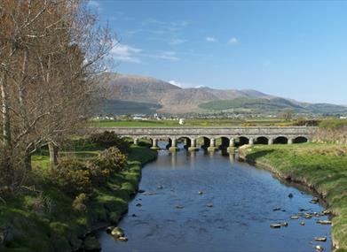
***Please note that the Ulster Way/ Lecale Way in Strangford village from Castle Street leading to Compass Hill, will be temporarily closed from 9th July 2018, for a period of three weeks, to facilitate structural repair work.*** The Lecale region of County Down is characterised by pretty villages, wild coastline and a liberal scattering of historic sites. This two-day walking route uses a combination of country roads, tracks and footpaths to explore the best of the scenery, with lowland terrain and frequent signposts making it suitable for most levels of walking experience. Section 1 Downpatrick to Audley's Castle The route starts along a series of tracks and country lanes. Begin by walking up a flight of stone steps beside the entrance to the St Patrick Centre. This brings you to English Street. Just 100m to the left lies Down Cathedral, and it’s well worth making the short detour to visit St Patrick’s grave at the left side of the building. Return down English Street and cross onto the pedestrian area at the bottom of Scotch Street. Follow this road uphill and where the main road swings right, keep straight ahead. Pass through a gateway and follow a footpath up a hillside. This is Gallow’s Hill, and a 100m detour from the top of the path affords fine views across Downpatrick town. Join a road and continue through a suburban housing estate. Follow the signs through four road junctions, and you’ll find yourself leaving Downpatrick along the Ballysallagh Road. This minor country road is bordered by high hedgerows, and is typical of many of the quiet roads you’ll follow over the next two days. After two left turns you arrive at the route’s first off-road section. A grassy footpath leads past hedges, woodland and fields on its way to the charming clachan of Ballstokes. From here a grassy track takes over, descending past the northern tip of Lough Money. Cross straight over the next road in the village of Raholp and follow another track to a field, which you should cross diagonally to the right. At the next road, taking care on the main Strangford Road, head right for 400m, then turn left. Follow a series of minor country roads for 3km, passing the entrance to Myra Castle. Turn left at the next two junctions, again taking care due to traffic on the main Strangford Road, then a further 3km of walking brings you along the stone wall marking the National Trust estate of Castle Ward to an informal parking area near Audley’s Castle. Did You Know? The Lecale area has a strong association with St Patrick, patron saint of Ireland. This route begins just metres from his grave, and passes within a kilometre of Ireland’s first church at Saul, and the country’s most extensive Holy Well complex at Struell Wells. St Patrick founded both places, and you’ll pass several similar sites as you progress along the walk. Section 2 Audley’s Castle to Kilclief The off-road trails along the shore of Strangford Lough provide the highlights of this section. From the parking area beside Audley’s Castle, turn left onto a track which then swings around the headland, displaying fine views across Strangford Lough to Portaferry. You now pass Audley’s Quay and arrive at an entranceway to the National Trust estate. Rather than going through the gates, turn left along the shore, then head through an archway on the right. Join a gravel avenue and turn left, walking through the trees above the shore. After 1.5km you exit the estate onto the main Strangford road. Here you have a choice of routes – either make a 3km loop around the charming village of Strangford, or continue directly south towards Kilclief. If you opt for the Strangford loop, head left along the main road, taking care with the traffic. After 500m, turn left onto a footpath beside a house. A track and footpath now bring you to the pebble-strewn shore of Strangford Lough, with the old tower house of Castle Ward guarding the opposite side of the bay. At the end of this section, follow a series of tracks up a wooded hill, then descend to the top of Castle Street in Strangford village. Take the first left to reach the pretty quayside, then follow the main road away from the ferry pier. Turn left after 1km to rejoin the direct route to Kilclief. The road to Kilclief continues through pastoral surrounds for some 3.5km before arriving at a T-junction. Turn left here, then negotiate three more junctions before passing Kilclief church and arriving at the base of Kilclief Castle. Did You Know? This section passes two tower houses on the shore of Strangford Lough, and finishes at a third. The region is dotted with similar buildings, which date back to the period when Portaferry was a major port. Most were constructed during the fifteenth or sixteenth centuries, spurred on by King Henry VI’s offer of £10 to anyone who would erect a tower to protect the coastline. Section 3 Kilclief to Ardglass Please note - the Northern Ireland Environment Agency (NIEA) may close the path between Ballyhornan and St Patrick's Well during October each year, to facilitate habitat conservation along the Sheepland Coast. This section incorporates dramatic natural scenery around the Ballyhornan Coastal Path. From the base of Kilclief castle, turn right and head along the road towards Ballyhornan village. After 2km the coastal heath of Killard Nature Reserve can be seen to the left. This merges into Ballyhornan Bay, which is backed by a wide stretch of sand a kilometre long. At the end of the beach, turn left in Ballyhornan village. A lane brings you down to the shore, where there are good views across to Gun’s Island. The lane soon dwindles to a track, then becomes a footpath running along the top of the foreshore. Please note: this stretch of path is rough and exposed in places with steep drops. Continue past a ruined coastguard station and around several more coves. The coastline becomes wilder and more dramatic as you continue, and you’re soon forced to the top of the cliffs by a steep inlet. The Mourne Mountains can now be seen to the southwest, while the Isle of Man is visible out to sea. Continue through longer grass to Sheepland, an abandoned settlement that was once home to a corn mill. The path now returns to sea level and continues to the wooden cross and enclosure surrounding St Patrick’s Well, a site associated with the saint’s arrival in County Down in 432 AD. Shortly beyond the well you arrive at a grassy lane. Follow this inland to a minor road, then turn left. After 1.5km you arrive at the main A2 Strangford-Ardglass road. Taking care of the traffic turn left here and follow the tarmac for 1km to arrive in the centre of Ardglass. Did You Know? As you walk between Kilclief and Killard Nature Reserve, look out across the coastal waters. If the tide is retreating the sea is likely to be turbulent, as 400,000 tonnes of tidal flow empties out of the narrow mouth of Strangford Lough. Little wonder that the Vikings named the inlet Strang Fjörthr, or ‘strong fiord’. Section 4 Ardglass to Tyrella Beach Most of this section follows roads, with a brief interlude along the Killough Coastal Path. From the centre of Ardglass, pass the pretty marina and head out of the village towards the A2. Pass through Coney Island and continue round the wide tidal flats of Killough Bay. As you approach the centre of Killough village, turn left through a metal turnstile onto a paved footpath. This delightful trail leads around the back of the church to the pier. If the tide is out you may well see locals collecting shellfish from the mudflats below. Return to the road and walk to the end of the village. Continue south onto Shore Road, where a stile on the left indicates the start of the Killough Coastal Path. Please note: this stretch of path is rough and exposed in places with steep drops. Follow a rough trail above the rocky shoreline, negotiating several stiles amid the wild terrain. As you round a series of inlets, the path is sometimes forced up to the edge of the fields to avoid a deep fissure. The lighthouse at St John’s Point comes into view near the end of the section, and you rejoin a laneway a short distance away from the building. Turn right along the lane, soon passing the remains of St John’s Point Church and Holy Well, which have survived remarkably intact from the 10th or 11th century. Continue along the quiet country road (laneway) for roughly 3km before arriving back at the A2. Turn left here and follow the road along the shore, with fine open views across Dundrum Bay to the Mourne Mountains. Towards the end of this coastal section you pass Tyrella Beach, a sandy beach some 2km long that is popular with holidaymakers during the summer months. Did You Know? St John’s Point Lighthouse was built in 1844, and was later extended to 40m high. However it was 1981 before the light became fully automatic. Today the distinctive black and yellow stripes of the tower make it stand out amongst the 81 lighthouses dotted around the Irish coast. Section 5 Tyrella Beach to Dundrum A series of roads now leads to a beautiful stroll along a disused railway line. Continue past Tyrella Beach on the A2, then turn left onto a minor road that carries you inland through the village of Ballykinler. Follow the road north out of Ballykinler for around 2.5km before returning to the A2. Turn left and cross Blackstaff Bridge then, 500m later, turn left again onto a minor road. The minor road takes a sharp right turn, leave the tarmac at the apex of the bend, continuing ahead and climbing a set of steps to reach the top of an old, stone railway bridge. You are now on the Dundrum Coastal Path, which follows the line of a dismantled railway along the shore of Dundrum Inner Bay. This beautiful stretch of trail takes you along a grassy corridor, with woodland on one side and the tidal inlet on the other. One particularly enjoyable section involves crossing your own personal causeway across a subsidiary bay. Wildlife is plentiful here too; rabbits scurry across the path ahead and at low tide you may see large flocks of wading birds picking their way across the mudflats in search of food. The southern end of the trail is marked by a National Trust sign and car park. Turn left along the main road, then veer left again onto a paved footpath that leads through a small stretch of parkland. Return to Main Street to pass through the centre of Dundrum village. Did You Know? The Dundrum Coastal Path follows the line of the old Belfast and County Down Railway, which once ran from Belfast to Newcastle. The Dundrum section opened in March 1869. At its height, the network consisted of 129km of track, with five branch lines covering much of Country Down. After operating for almost 100 years, the railway finally closed in 1950. Section 6 Dundrum to Newcastle Almost all of the final section is off-road, with the dunes and sands of Newcastle Beach providing a fitting finale. At the southern end of Dundrum, passing St Donard’s Church of Ireland on the right, take the next turn left onto an off-road path which leads through a small plantation of trees on to Keel Point. Cross the three stone arches of the Downshire Bridge, then turn right onto a gravel track. If you look back across the estuary towards Dundrum you’ll get a fine view of the village, guarded by the hilltop ruins of its medieval castle. The track leads along the final stretch of Dundrum Inner Bay. Shortly before you reach the A2 road, a footpath veers left into Murlough National Nature Reserve. Follow a wooden boardwalk across the site, undulating through the dunes and coastal heath. As you exit the dunes and drop down onto the beach, a wonderful sight meets your eyes. The Mourne Mountains now seem just a stone’s throw away, rising majestically above the sweep of the bay. Turn right and follow the beach south for almost 3km. The terrain underfoot varies between firm sand and small pebbles, and depending on the state of the tide you may either have a wide space or a narrow strip at your disposal. As you approach Newcastle town, the first building you encounter is the Slieve Donard Hotel, with its imposing Victorian facade. Shortly beyond this, climb a set of steps to reach the wide pavement of the town promenade. Make your way south along the waterfront to a white metal footbridge across the Shimna River. Cross the bridge, and keep left along the promenade. Take the next right turn through the small car park to finish at the Newcastle Tourist Information and the official end of the route. Did You Know? The sand dune ecosystem of Murlough National Nature Reserve is 6000 years old, and is regarded as the best and most extensive example of dune heath in Ireland. The area was designated as Ireland’s first nature reserve in 1967, and is now home to 22 species of butterfly and an array of wildflowers. Please be aware that this walking route passes through areas of open land such as working farmland and tidal zones. Livestock may be present and ground conditions may be uneven or wet underfoot. Please refer to the ‘Walk Safely’ information that can be found at the link below.
Distance:
47 miles
Terrain:
Paths, beach and quiet road
Point of interest:
St Patrick's Centre, Downpatrick Steam Railway, Down Cathedral, Down Museum, Gallows Hill, Struell Wells, St Patrick's Monument, sandy beaches, seabirds and seals
Facilities:
Toilets, accommodation and refreshments are available all the way along the walk including the villages and towns of Downpatrick, Strangford, Ardgalss and Newcastle.
Publication:
Lecale Waymarked Way Guide.
Publication availability:
Contact Downpatrick Visitor Information Centre 028 4461 2233. Alternatively, a copy of the Guide is available to download on this webpage.
Nearest town:
Downpatrick
OS map:
Sheets 21 & 29
Book Tickets
Facilities
Provider Preferences
- Free (parking charges may apply)


