

Book Tickets Online
About
This two-day, circular walking route offers a rich snapshot of life in rural County Down. Ideal for fit walkers, the journey features a mix of lowland terrain, forest trails, quiet country lanes, and the long golden stretch of Newcastle Beach. The route is infused with scenic variety and set against the backdrop of traditional seaside hospitality in Newcastle.
- Start and Finish Point: Grid Reference J377309
-
Distance: 28 miles (45 km)
-
Terrain: Mostly gravel paths, minor roads, beach, and forest tracks
-
OS Map: Sheet 29
-
Facilities: Toilets in Tollymore Forest Park, Castlewellan Forest Park, and Newcastle; refreshments available along the route
-
Accessibility: Mostly gravel paths with some minor roads and occasional steep gradients; clearly signposted
Day 1: Newcastle to Castlewellan via Murlough
Section 1: Newcastle to Murlough
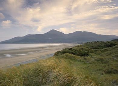
From Newcastle Visitor Information Centre, walk 100m north along Central Promenade to the bridge over the Shimna River. Turn right, then left over the white metal footbridge, and continue north along the promenade. At the town's northern end, descend steps onto the sand and walk beneath the Slieve Donard Hotel. Depending on the tide, you may have ample space or a narrow strip along the dunes.
After about 2 km, Murlough Nature Reserve begins on your left. Continue to the beach's end, roughly 5 km in total. As the coast curves left, follow the narrow channel of Dundrum Inner Bay. Midway along, pass the old boat house. The village of Dundrum is visible across the estuary, crowned by Dundrum Castle. The trail leaves the shore just before Downshire Bridge, joining a gravel path that leads to the A2 road.
Did You Know?
-
Murlough’s sand dune system is over 6,000 years old and was Ireland’s first designated nature reserve (1967).
-
Look out for common and grey seals, with populations peaking from July to October.
Section 2: Murlough to Castlewellan
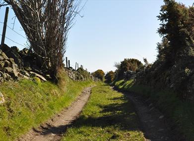
Cross the A2 and continue across the Carrigs River. Take the first left onto a quiet rural lane flanked by hedgerows and farmland. Look for a prehistoric standing stone along the verge. At the lane’s end, turn left into Maghera village—a perfect spot for a break.
Optional Detour: Turn left at the humpback bridge in Maghera to visit the 13th-century Maghera Old Church and round tower base.
Return to the route by turning right onto a grassy track 300m beyond the humpback bridge. The path climbs between fields (can be muddy) before becoming a firmer gravel track. Continue through traditional farmland, and take a right turn onto a paved lane. Climb over a hill, enjoying coastal views, then descend and turn left at the A25. Climb to reach Castlewellan’s Upper Square near the old market house (built in 1764, now a public library).
Did You Know?
-
This section follows historic rights of way still used by farmers and walkers.
-
The route is rich in stone-walled fields, iron gates, and vintage farm buildings.
Day 2: Castlewellan to Newcastle via Tollymore
Section 3: Castlewellan Forest Park
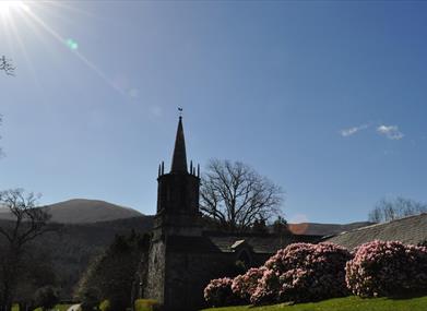
From the old market house, turn right and enter Castlewellan Forest Park. Walk past grassy meadows to Castlewellan Castle, built in 1856 in Scottish baronial style. Climb behind the castle and continue along a forest track through beech woodlands above the lake.
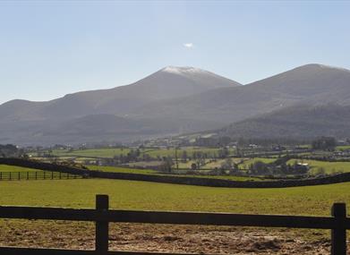
At the lake’s northern tip, turn left past Cypress Pond. Descend to the main lake trail, then turn right to follow the shoreline to a viewpoint at the lake’s western edge. Turn left and climb through woodland with views toward the Mourne Mountains. Near the southwest park corner, take a right off the track to descend through fields to the exit gate. Turn left at the road and again at the roundabout to return to Castlewellan town.
Did You Know?
-
The Annesley family developed Castlewellan town and park from 1742, enclosing 350 acres and commissioning a French architect.
Section 4: Castlewellan to Bryansford
From Castlewellan’s roundabout, turn right onto the A50 for 300m, then right into a housing estate. Continue through to a grassy footpath descending into a hollow. Cross two metal footbridges and climb again across meadows, locally known as ‘Cow Lane.’
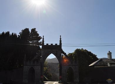
Exit through a gate to a country lane, turn left for 800m, then right onto Green Lane. Climb steeply and continue left at the top onto a quiet lane for nearly 2 km. The section ends at the B180 junction in Bryansford, where Bryansford Gate marks the entrance to Tollymore Forest Park.
Did You Know?
-
Folklore warns of the Dullahan, a headless horseman said to haunt the Bryansford area.
Section 5: Tollymore Forest Park
Pass through Bryansford Gate and follow the drive past 18th-century Clanbrassil Barn to the parking area. Join the Black Trail, cross a wooden footbridge into beech woodland (blooming with bluebells in spring), and descend towards the Shimna River.
Cross Parnell’s Bridge and trace the western park boundary, with views of Slieve Commedagh (767m). Continue through pine forest, descend to Hore’s Bridge, and climb again to the boundary wall. The track descends in a sweeping curve with expansive views of Dundrum Bay.
Section 6: Tollymore to Newcastle
Exit the park through a wooden gate and follow a narrow tarmac lane downhill. Turn right at a larger road, then left onto Tipperary Lane. Descend through Tipperary Wood and past a scout campsite. Turn left onto Bryansford Road and cross the Shimna River.
Enter Islands Park and follow the river path to a footbridge. Cross into Castle Park, passing the boating lake, before reaching Newcastle’s Central Promenade. The tourist office is 100m to your right.
Did You Know?
The Shimna River, although scenic, is prone to flooding. Despite mitigation efforts, the river still poses challenges for the town.
Key Points of Interest
-
Murlough Bay: Dunes, seals, and coastal views
-
Castlewellan Forest Park: Lake, castle, and arboretum
-
Tollymore Forest Park: Woodland trails and river crossings
Safety Notes
This route includes open land, hillside, active farmland, and forestry operations. Livestock may be present. Ground conditions may be uneven or wet. Please follow all posted signage and refer to local ‘Walk Safely’ guidelines.
Additional Resources
-
Publication: Newcastle Way
-
Available at: Newcastle Visitor Information Centre
Book Tickets
Facilities
Provider Preferences
- Free (parking charges may apply)


