Official tourism website for Mourne Mountains and Ring of Gullion
En

Tollymore Forest Park - River Trail

Co Down
Tollymore Forest Park - River Trail

Book Tickets Online

About

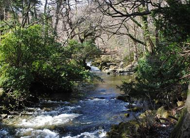
Having descended the Azalea Walk to the Shimna River, the trail turns upstream along the attractive tree lined river bank past the Hermitage to cross the river at Parnell's Bridge. The 10 metre cascade fall is most spectacular.

Start Point:
J343325

Finish Point:
J343325

Route:
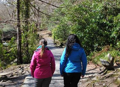
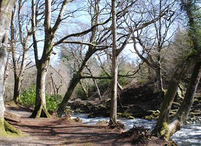
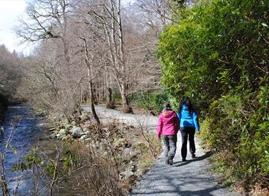
Follow the red waymarker arrows from the car park. Down the Azalea Walk towards the Shimna river to the Hermitage this trail passes through both conifer and broadleaved woodland before crossing the Shimna at Parnell’s bridge. Dramatic views of the Pot of Legawherry can be seen from the trail. There is an optional spur to the White Fort Cashel before following the Spinkwee River downstream, past the cascades and back to the Meeting of the Waters. The trail proceeds through conifer plantations, past the duck pond and crosses the Shimna River over the Old Bridge, returning to the car park via the Green Rig. Trail Features Steps, gullies, tree roots Moderate gradient (1:4) Generally undefined edges Overhanging branches Broken surface material Some rest areas at irregular intervals Way-finding markers at trail junctions Distance to go Markers at trail junctions These walks are situated in a working forest environment and may be subject to diversion and closure from time to time. Up to date information is available on the Forest Service web site - link below.

Distance:
3.1 miles

Terrain:
Easy off-road paths

Point of interest:
Shimna River, the Hermitage, Parnell's Bridge, the Cascades

Facilities:
Car park (fee charged), toilets (disabled access), picnic areas, camping and caravaning, electronic 'In-Touch' information kiosk, way-marked/ nature trails, guided tours available.

Publication:
None

Nearest town:
Newcastle

OS map:
Sheet 29

Accessible toilet facilities:
Yes

Accessible terrain:
Unsurfaced forest paths

Facilities

Provider Preferences

  • Free (parking charges may apply)

Map & Directions

What's Nearby

  1. Tollymore Forest Park has panoramic views of the surrounding mountains and the sea at…

    0.04 miles away
  2. Maghera Church and Round Tower is of major historical importance and is among many…

    1.98 miles away
  3. The Mourne Area of Outstanding Natural Beauty is located in the south-east corner of…

    2.17 miles away
  1. The Shimna River is a river in County Down, Northern Ireland. It rises on the slopes of…

    2.2 miles away
  2. The Mourne Coastal Route has a few start off points from the County Down coastline,…

    2.2 miles away
  3. The High Mournes Scenic Loop delves into the very heart of the famous Mourne Mountains…

    2.2 miles away
  4. Newcastle's Parks consist of outdoor facilities at the Castle and Island parks. Castle…

    2.2 miles away
  5. The Mourne Wall is 22 miles long and consists of natural granite stone which was…

    2.28 miles away
  6. Newcastle Beach is a popular seaside resort and tourist destination located on the South…

    2.3 miles away
  7. Donard park is a beautiful park located in the lovely town of Newcastle County Down, next…

    2.31 miles away
  8. A small car park for visitors is located off the Drumnaquoile Road and an extensive…

    2.32 miles away
  9. Situated on the "Winding Road to Clanawillan" (Trassey Road), Meelmore Lodge is the best…

    2.38 miles away
  10. Castlewellan Peace Maze is located in Castlewellan Forest Park on Forest Park View,…

    2.44 miles away
  11. Newcastle is a small drying harbour with fixed fore/aft moorings and consists of two…

    2.45 miles away
  12. The Maize Maze is the only one of its kind in Northern Ireland. A massive 6 acre field of…

    2.75 miles away
  13. The Castlewellan Arboretum and Annesley Garden is situated north of the foothills of the…

    2.88 miles away
Previous Next

Map & Directions

Road Directions

Signposted from Newcastle. Take the road to Bryansford and the entrance to Tollymore Forest Park is on the left.

Public Transport Directions

Translink - journeyplanner.translink.co.uk

View Maps and Visitor Guides
View what the Mourne Mountains & Ring of Gullion has to offer and some of the best things to see and do during a visit.
E-newsletter sign up
Sign up for the Mourne Mountains & Ring of Gullion newsletter for inspiration and travel tips.
Back to Top

Visit Mourne

Tourism Northern Ireland

Geopark

Don't Miss