Official tourism website for Mourne Mountains and Ring of Gullion
En

Reservoir Views

Co Down
Reservoir Views

Book Tickets Online

About

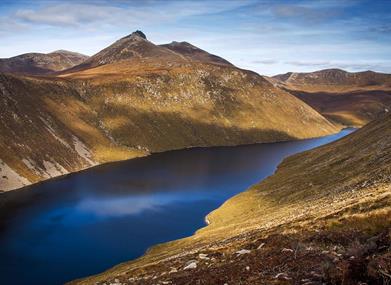
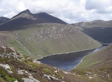
A strenuous linear walk linking the south Mournes to Newcastle via Slieve Binnian, Slievemalagan and the Glen River. Impressive views of Silent Valley Reservoir can be enjoyed from Slieve Binnian and of Ben Crom Reservoir from Slievelamagan, both of which supply Belfast with piped water.

Start Point:
J345219

Finish Point:
J355376

Route:
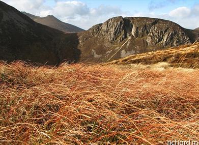
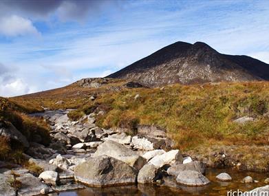
From Carricklittle car park, take the track northwards for 1km and cross the Mourne Wall using the stile/gate provided. After a short distance leave the track and continue along the Mourne Wall for 2km ascending the eastern slope of Slieve Binnian (747m). This section starts off gently sloping before ascending steeply to the summit tor. Descend Slieve Binnian northwards using the line of the tors, passing the Back Castles. Continue along this well eroded path for 2 km passing the north tor and descending steeply northwards to the col with Slievelamagan. Continue straight ahead to ascend Slievelamagan (704m). Continue northwards on the well worn path, to the col between Slievelamagan and Cove mountain. From here follow the path over Cove Mountain along the top of the crags. Continue along this path northwards to Slieve Beg passing the Devil's Coach Road. Care should be taken here, especially in windy conditions. The path meets the Brandy Pad 0.5 km after this point. Continue in an easterly direction along the Brandy Pad passing under the craggy outcrops of The Castles on the left. At the end of the Castles veer left and ascend to the col between Slieve Commedagh and Slieve Donard. Cross the Mourne Wall using the stile provided. Follow the Glen River Path downhill for 4km. The well trodden path parallels the Glen River first in the valley floor and then through Donard Wood to the Donard car park in Newcastle, where the route ends. Another option to include within your route would be to summit Slieve Donard. After following the Brandy Pad past The Castles, instead of crossing the wall and continuing down the Glen River Valley towards Newcastle, turn right at the wall and summit Slieve Donard. Descend the same way and follow the Glen River Path towards Newcastle as above.

Distance:
9.3 miles

Terrain:
Uneven mountain paths

Point of interest:
The Mourne Wall, Slieve Binnian, Cove Mountain, Slieve Beg, The Devils Coachroad, The Castles, the Glen River.

Facilities:
Car park available at Carricklittle and Donard Park in Newcastle. Toilet facilities also available in Donard Park.

Nearest town:
Annalong/Newcastle

OS map:
29

Accessible terrain:
no

Accessible signage:
no

Facilities

Provider Preferences

  • Free (parking charges may apply)

Map & Directions

What's Nearby

  1. Annalong Cornmill has been beatifully restored and is situated by the pretty Annalong…

    2.28 miles away
  2. The Silent Valley Reservoir was built to gather water from the Mourne Mountains and is…

    2.55 miles away
  3. Provides a first class service for visitors to Northern Ireland and for local residents.

    5.12 miles away
  1. The Nautilus Centre overlooks Kilkeel's busy and picturesque fishing port and houses the…

    5.18 miles away
  2. Donard park is a beautiful park located in the lovely town of Newcastle County Down, next…

    5.61 miles away
  3. The Mourne Wall is 22 miles long and consists of natural granite stone which was…

    5.64 miles away
  4. The High Mournes Scenic Loop delves into the very heart of the famous Mourne Mountains…

    5.92 miles away
  5. The Mourne Coastal Route has a few start off points from the County Down coastline,…

    5.92 miles away
  6. Newcastle's Parks consist of outdoor facilities at the Castle and Island parks. Castle…

    5.93 miles away
  7. The Electric Brae is a hill at which Newton's discovery, the law of gravity, is defied…

    5.98 miles away
  8. Spelga Dam Reservoir sits in the heart of the Mourne Mountains, located approximately 10…

    5.98 miles away
  9. Situated on the "Winding Road to Clanawillan" (Trassey Road), Meelmore Lodge is the best…

    6.12 miles away
  10. Newcastle Beach is a popular seaside resort and tourist destination located on the South…

    6.26 miles away
  11. Tollymore Forest Park has panoramic views of the surrounding mountains and the sea at…

    6.61 miles away
  12. Maghera Church and Round Tower is of major historical importance and is among many…

    7.74 miles away
  13. This 5 mile stretch of golden sands is still the essence of the resort and is hugely…

    7.82 miles away
Previous Next

Map & Directions

Road Directions

The walk starts at Carricklittle car park. To get here follow the Moneydarragh Road out of Annalong for 1.3 km, continue straight on at the crossroads on the Oldtown Road for 2.4 km, Carricklittle car park is at the end of the Oldtown Road.

Public Transport Directions

Translink - journeyplanner.translink.co.uk

View Maps and Visitor Guides
View what the Mourne Mountains & Ring of Gullion has to offer and some of the best things to see and do during a visit.
E-newsletter sign up
Sign up for the Mourne Mountains & Ring of Gullion newsletter for inspiration and travel tips.
Back to Top

Visit Mourne

Tourism Northern Ireland

Geopark

>

Don't Miss