Official tourism website for Mourne Mountains and Ring of Gullion
En

Devil's Coachroad Guided Hike

Down, Warrenpoint, Annalong, Down, BT34 3SA
Devil's Coachroad, Slieve Beg in the Mourne Mountains

About

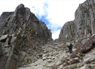
The Devil's Coachroad


Without doubt the most talked about challenge in the Mourne Mountains and for good reason!!!

But you can crack it with the help of two qualified and experienced guides from Walk the Mournes, we will make sure you have a day to remember.

Not only will you experience some of the most spectacular views the Mournes have to offer we will also give you some tips on scrambling and kit choice, and we will also share a wealth of knowledge about the geology, flora and fauna of the mountains.

This hike is graded Hard and involves some scrambling (use of hands and feet), a good level of fitness is required.

Facilities

Event Facilities

  • Booking Required

Parking & Transport

  • On site parking

Guide Prices

Min-Max Numbers: 6-12 / Duration: 6 Hours (Approx)
Price per person: £59

Book Tickets Online

Add Devil's Coachroad Guided Hike to your Itinerary

Check availability for Devil's Coachroad Guided Hike (opens in a new window)

Close window

Call direct on:

Tel +44 (0) 79 7476 8831

Map & Directions

Opening Times

Sorry, this event has passed

What's Nearby

  1. Annalong Cornmill has been beatifully restored and is situated by the pretty Annalong…

    1.18 miles away
  2. The Silent Valley Reservoir was built to gather water from the Mourne Mountains and is…

    3.64 miles away
  3. Provides a first class service for visitors to Northern Ireland and for local residents.

    4.03 miles away
  1. The Nautilus Centre overlooks Kilkeel's busy and picturesque fishing port and houses the…

    4.04 miles away
  2. Donard park is a beautiful park located in the lovely town of Newcastle County Down, next…

    7.35 miles away
  3. The Mourne Wall is 22 miles long and consists of natural granite stone which was…

    7.38 miles away
  4. The High Mournes Scenic Loop delves into the very heart of the famous Mourne Mountains…

    7.66 miles away
  5. The Mourne Coastal Route has a few start off points from the County Down coastline,…

    7.66 miles away
  6. Newcastle's Parks consist of outdoor facilities at the Castle and Island parks. Castle…

    7.67 miles away
  7. Cranfield Beach - an Inclusive Beach An 'inclusive beach' is a beach environment that…

    7.74 miles away
  8. Cranfield West offers a gently sloping, mainly sandy beach located at the entrance to…

    7.75 miles away
  9. The Electric Brae is a hill at which Newton's discovery, the law of gravity, is defied…

    7.88 miles away
  10. Spelga Dam Reservoir sits in the heart of the Mourne Mountains, located approximately 10…

    7.88 miles away
  11. Newcastle Beach is a popular seaside resort and tourist destination located on the South…

    7.98 miles away
  12. Commanding the mouth of Carlingford Lough, the Castle has an eventful history. It was…

    8.19 miles away
  13. Situated on the "Winding Road to Clanawillan" (Trassey Road), Meelmore Lodge is the best…

    8.27 miles away
Previous Next

Map & Directions

Road Directions

Directions sent after booking

Public Transport Directions

N/A

View Maps and Visitor Guides
View what the Mourne Mountains & Ring of Gullion has to offer and some of the best things to see and do during a visit.
E-newsletter sign up
Sign up for the Mourne Mountains & Ring of Gullion newsletter for inspiration and travel tips.
Back to Top

Visit Mourne

Tourism Northern Ireland

Geopark

>

Don't Miss