


Book Tickets Online
About
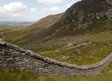
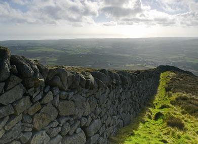
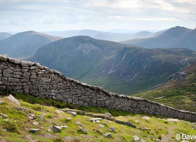
A highly challenging route taking in 7 of the 10 highest mountains in the Mournes and Northern Ireland, by following the historic Mourne wall. Group numbers of no higher than 12 should attempt this route in one go, due to erosion issues around the fragile Mourne wall.Start Point:
J345219
Finish Point:
J345219
Route:
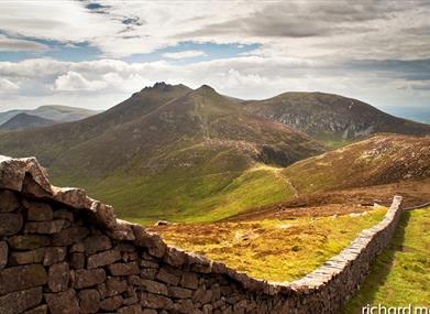
From Carricklittle car park, take the track northwards for 1 km and cross the Mourne Wall using the stile provided. Follow the Mourne Wall to the north west and ascend Slieve Binnian (747m). The wall rises steeply on the rugged slopes of Slieve Binnian, but it is an obvious line to follow almost all the way to the summit. There is a break when the wall runs into a bare face of granite, and before this point you should bear right and aim for a notch in the top of the mountain. Going all the way to the summit involves easy scrambling to summit the tors and taking care on the rock. The reward is a fine panorama of the surrounding mountains. In clear weather it's possible to see the Isle of Man out to sea and the Wicklow Mountains beyond Dublin. Continue following the Mourne Wall in a south westerly direction, descending steeply to Wee Binnian and across Moolieve. Continue the descent following the Mourne Wall to Silent Valley Mountain Park. A network of paths lead west across to the other side of the park. You can cut across at this point and travel west to regain the wall or continue following the wall south until the wall ends at the junction of Head Road and the entrance to Silent Valley Park. Continue in a westerly direction along Head Road for 1km and regain the wall where it meets Head Road after the forested area to the north ends. Continue along the wall in a northerly direction for 1.5 km where the wall takes a sharp westerly turn. After 500m, there is a junction of two walls, follow the wall to the north east to ascend Slievenaglogh. Descend Slievenaglogh following the Mourne Wall in a north westerly direction, crossing the Bann Road and steeply ascending towards Slieve Muck (674m). At the summit of Slieve Muck, take the northerly fork in the Mourne Wall. Continue east along this route to the summit of Carn Mountain (588m). Follow the Mourne Wall, passing Lough Shannagh on the right. Continue following the Mourne Wall to traverse the summits of Slieve Loughshannagh (619m) and Slieve Meelbeg (708m), up to the summit of Slieve Meelmore (687m). Continue to descend steeply following the wall in a south easterly direction, cross Pollaphuca and ascend Slieve Bearnagh (739m). Continue following the Mourne Wall in a north easterly direction to descend into Hare’s Gap. From Hare’s Gap ascend Slievenaglogh (586m). Continue following the wall in an east to south easterly direction to ascend Slieve Commedagh. Excellent views of Newcastle, Donard Wood and the Glen River can be enjoyed here. Continue east along the wall to ascend the highest mountain in Northern Ireland, Slieve Donard (853m). The summit provides spectacular views of the coast and as far afield as Belfast, 30 miles north, and Dublin, 55 miles to the south. Continue descending along the Mourne Wall in a southerly direction where the Bog of Donard spreads out before you. Continue along the Mourne Wall skirting past Chimney Rock Mountain to the east and Rocky Mountain to the west. From the north east side of Rocky Mountain, the wall trends south east towards Long Seefin. From here the 90 degree turn in the wall will lead you towards Annalong Wood. Continue following the wall for 500m, to meet a minor untarred road. Follow this road in a south easterly direction to meet the Head Road at Rourkes Park. Follow the Head Road in a westerly direction for 1.5km back to Carricklittle car park. Please be aware that this walking route passes through areas of open land such as hillside, working farmland and working forests. Livestock may be present, ground conditions may be uneven or wet underfoot and all forestry signage should be adhered to. Please refer to the ‘Walk Safely’ information that can be found at the link below.
Distance:
22 miles
Terrain:
Single file mountain track
Point of interest:
Slieve Binnian, Slieve Muck, Carn Mountain, Slieve Loughshannagh, Slieve Meelbeg, Slieve Meelmore, Slieve Bearnagh, Slieve Commedagh, Slieve Donard.
Facilities:
Car park available at Carricklittle and Silent Valley (charge applicable at Silent Valley). Coffee shop open 11.00am-6.30pm every day June, July, August, weekends and Bank Holidays during April, May, September. Visitors Centre and toilet facilities available at Silent Valley.
Nearest town:
Hilltown
OS map:
29
Book Tickets
Facilities
Provider Preferences
- Free (parking charges may apply)


