Official tourism website for Mourne Mountains and Ring of Gullion
En

Dundrum Coastal Path

Co Down
Dundrum Coastal Path

Book Tickets Online

About

The trail begins in the small National Trust carpark to the north of Dundrum village, located just off a grassy trail. From the car park head towards the waters of Dundrum Inner Bay and turn left onto the grassy track, part of an old railway line. Continue along the trail following the waymarkers if necessary. Approximately 1mile/1.7km from the start point, the route goes along an artificial embankment that carries the track across the Inner Bay. To the west of the trail the stone built Ardilea Bridge is visible. Continue along the path until reaching a junction with a set of stone steps where you will have reached the end of the trail -retrace your steps back to the start point. Cyclists can return to the carpark by the same route.

Getting to the start of Dundrum Coastal Path

Turn right off the main A2 from Belfast to Newcastle, just a few hundred yards before entering Dundrum village to reach the small National Trust car park.

Traffic

The path forms part of the Lecale Way and is popular with walkers. Also be respectful of birdwatchers.

Start Point:
J409373

Finish Point:
J422394
 

Distance (one way):
1.6 miles/2.5km

Terrain:
Grassy track

Points of interest

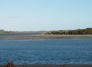
To the east of the trail are the waters of Dundrum Inner Bay or at low tide its estuarine sands and muds. The area is of very high interest for its marine life and is part of the Murlough Special Area of Conservation. It is important for wildfowl and waders in the winter such as oystercatcher, lapwing, redshank, curlew, black-tailed godwit, turnstone and grey plover due to the relatively mild climate and abundance of food found on the mudflats.

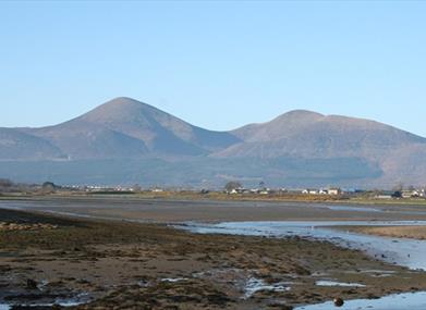
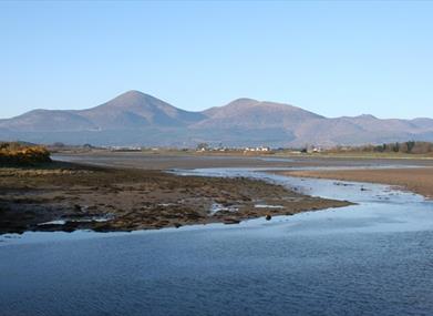
The gentle shelving shoreline of Dundrum Inner Bay merges with the shingle and dunes of Murlough. Across the Bay lie the fertile plains of Lecale while behind the village on the summit of a rocky hill, stands one of Northern Ireland's most evocative medieval ruins - Dundrum Castle.

Facilities
In Dundrum village there are carparks, bike racks, picnic tables and National Trust holiday cottage and places to eat. The National Trust coffee shop is available at the nearby Murlough main carpark.

Publications
Lecale Way leaflet-available to download from here.

Publication availability:
Walk NI


Nearest town/village:
Dundrum

OS map:
Sheet 29


Map of Dundrum Coastal Path


Facilities

Provider Preferences

  • Free (parking charges may apply)

Add Dundrum Coastal Path to your Itinerary

Map & Directions

What's Nearby

  1. Believed to have been built in or around 1177, Dundrum Castle was built by John De Courcy…

    0.42 miles away
  2. Set in spectacular surroundings overlooking Dundrum inner Bay these fine Georgian…

    0.86 miles away
  3. We are a family run farm park based just outside Newcastle, County Down. Established in…

    0.91 miles away
  1. An Anglo-Norman motte-and-bailey earthwork castle dating to the late 12th or early 13th…

    1.84 miles away
  2. Murlough National Nature Reserve is a fragile 6000 year old sand dune system owned by the…

    1.93 miles away
  3. The Maize Maze is the only one of its kind in Northern Ireland. A massive 6 acre field of…

    2.55 miles away
  4. This 5 mile stretch of golden sands is still the essence of the resort and is hugely…

    2.55 miles away
  5. Maghera Church and Round Tower is of major historical importance and is among many…

    3.09 miles away
  6. Tyrella beach and conservation area is a small, enclosed dune complex within Dundrum Bay.…

    3.7 miles away
  7. Seaforde Gardens, Maze and Tropical Butterfly House promises a truly plant rich and…

    3.91 miles away
  8. Newcastle Beach is a popular seaside resort and tourist destination located on the South…

    4.11 miles away
  9. A small car park for visitors is located off the Drumnaquoile Road and an extensive…

    4.33 miles away
  10. Newcastle's Parks consist of outdoor facilities at the Castle and Island parks. Castle…

    4.45 miles away
  11. The Mourne Coastal Route has a few start off points from the County Down coastline,…

    4.46 miles away
  12. The High Mournes Scenic Loop delves into the very heart of the famous Mourne Mountains…

    4.46 miles away
  13. Interactive Medieval history Village, offering the opportunity to step back in time and…

    4.53 miles away
Previous Next

Map & Directions

View Maps and Visitor Guides
View what the Mourne Mountains & Ring of Gullion has to offer and some of the best things to see and do during a visit.
E-newsletter sign up
Sign up for the Mourne Mountains & Ring of Gullion newsletter for inspiration and travel tips.
Back to Top

Visit Mourne

Tourism Northern Ireland

Geopark

>

Don't Miss