Official tourism website for Mourne Mountains and Ring of Gullion
En

Electric Mountain Biking on the Rostrevor Red Trail – Bike Mourne

Rostrevor Forest Park, Rostrevor, County Down, BT34 3AA
Electric Mountain Biking on the Rostrevor Red Trail – Bike Mourne

Book Tickets Online

About

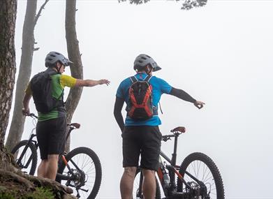
The Rostrevor Mountain Bike Trail Centre is one of our National Trail Centres and one of the most popular Trail Centres in Ireland.
With a mouth-watering 27km red trail, Rostrevor MTB Trail Centre is believed by many to be the top spot for Mountain Biking in Ireland… add an Electric Bike and it’s a whole new level!

On the shores of Carlingford Lough, adjacent to the lively village of Rostrevor, the Rostrevor Mountain Bike Trails Red Route offers some challenging mountain biking where efforts are rewarded with incredible coastal views and exhilarating single-track descents.

From the heights of Slievemartin, where you enjoy the breath-taking views over Carlingford Lough, you will then be able to enjoy a number of exciting descents and sections of northshore over to Yellow Water where the trail turns back and follows the Kilbroney Valley back to the trailhead.

Self-Guided options available daily – pre-booking online required.

Package includes;
Map – you’ll be supplied with an easily followed route map including route description and key local tips!
Bike – powered by the awesome CUBE Bikes
Helmet – must be worn by the rider at all times
Accessories – we supply a lock, tool, tube and pump
Charge - electric assist bikes come with 1 full charge – for hires beyond 6h, we supply a charge cable
Support number – available 9am-5pm for telephone assistance
Damage Waiver – accidents happen! So we’ve protected you against accidental damage to the bike with our Waiver Scheme – excludes loss/damage to accessories including the use of the spare tube - see 'Top Up' option

Distance: 27Km
Duration: 4-6 hours
Price: varies depending on bike choice and start from £42.00

Bespoke-Guided options available - pre-booking direct with our team required

Facilities

Children & Infants

  • Suitable for Children

Establishment Features

  • Groups catered for
  • Lessons/courses available
  • Online Booking
  • Prior Booking Required

Parking & Transport

  • On site parking

Payment Methods

  • All major credit/debit cards accepted
  • Euros accepted

Add Electric Mountain Biking on the Rostrevor Red Trail – Bike Mourne to your Itinerary

Check availability for Electric Mountain Biking on the Rostrevor Red Trail – Bike Mourne (opens in a new window)

Close window

Call direct on:

Tel +44 (0) 28 4377 0714

Map & Directions

Opening Times

* 09:00 - 17:00

What's Nearby

  1. Kilbroney Park features riverside walks and an arboretum. There is a two-mile forest…

    0.12 miles away
  2. This beautiful area has superb views and good walking routes over Carlingford Lough.…

    0.14 miles away
  3. 'Cill Bhronaigh', or Bronagh’s Church (12th century), is located in the graveyard just…

    1.11 miles away
  1. Our play farm offers a huge indoor soft play area with four dragon slides and a massive…

    2.2 miles away
  2. Warrenpoint Beach is located alongside the Mourne Mountains on the shores of Carlingford…

    2.45 miles away
  3. Excellent example of a tower-house and bawn built about 1568 at a point where the Newry…

    3.85 miles away
  4. "Where the Mountains of Mourne sweep down to the sea" (Percy French)

    The popular song…

    4.5 miles away
  5. Commanding the mouth of Carlingford Lough, the Castle has an eventful history. It was…

    5.28 miles away
  6. Known locally as the ‘King’s Ring’, this court tomb has a prominent position in the…

    5.48 miles away
  7. Cranfield West offers a gently sloping, mainly sandy beach located at the entrance to…

    6.56 miles away
  8. The Silent Valley Reservoir was built to gather water from the Mourne Mountains and is…

    7.73 miles away
  9. The Electric Brae is a hill at which Newton's discovery, the law of gravity, is defied…

    7.77 miles away
  10. Spelga Dam Reservoir sits in the heart of the Mourne Mountains, located approximately 10…

    7.77 miles away
  11. Kilnassagart Inscribed Stone, in the south of County Armagh, is regarded as being one of…

    7.87 miles away
  12. Dating from the Iron Age period around 10 BC, the enclosure comprises two roughly…

    8.01 miles away
  13. Leisleitrim Fort is a fine example of a multivallate rath ( a rath with several banks and…

    8.01 miles away
Previous Next

Map & Directions

View Maps and Visitor Guides
View what the Mourne Mountains & Ring of Gullion has to offer and some of the best things to see and do during a visit.
E-newsletter sign up
Sign up for the Mourne Mountains & Ring of Gullion newsletter for inspiration and travel tips.
Back to Top

Visit Mourne

Tourism Northern Ireland

Geopark

>

Don't Miss