


Book Tickets Online
About
From Newry Town Hall cycle 30m along the west side of the canal and turn left on to Sugar Island. Follow on to Canal Street and follow the A28 using the cycle lane for one mile until the Five Ways roundabout. Turn left on the A1 and immediately turn right on to the Craigmore Road. Follow the road for 0.8 miles until arriving at a T-Junction with Kidds Road. Turn left passing over the crossroads with the B113 for 0.8 miles until the T-Junction with Derrymore Road. Turn right and then left in to Derrymore after 100m. Continue on the off road trail and turn left at the junction in front of Derrymore House. This leads to the Newry Road (A25). Turn left and immediately right on to the Limekiln Road. Follow the road around until a T-Junction with the Carrivekeeney Road. Turn right and follow the road for one mile on to Church Rock and in to Camlough. Turn left on to Keggall Road with Cam Lough on the right hand side for three miles until Murrays Corner. Turn right on to Church Road until the T junction with Ballintemple Road with Killevy Churches immediately in front. Turn left and continue past Clonlum Cairn for one and a half miles to the crossroads with Wood Road. Turn right in to Slieve Gullion Forest Park and the Courtyard.Public roads: On Public Road
Getting to the start: The Start is outside Newry Town Hall. Between Sugar Island and Hill Street. The location can be accessed from the Trevor Hill and Water Street Junction which is the main route running North-South from the Belfast Road to the Dublin Road. There is long stay parking behind the Courthouse in New Street which can also be accessed from Sugar Island. A short walk leads to the Town Hall.
Traffic: There is a cycle lane on the A28 out of Newry. The route crosses the busy A1dual carriageway just past the Fiveways Roundabout and the A25 South of Derrymore House.
Start Point:
J085268
Finish Point:
J043197
Distance:
10 miles
Terrain:
Mainly undulating scenic minor country roads with a cycle lane on the A28 out of Newry and off road section within Derrymore.
Point of interest:
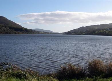
The National Trust property of Derrymore House where the Act of Union between Britain and Ireland was drafted. Vibrant Camlough Village to shop, eat and drink. Cam Lough, a glacial ribbon lake and Area of Special Scientific Interest. Killevy Churches dating from the 10th Century and the burial place of St Moninna. The unusual megalithic 4000 year old Clonlum South Burial Cairn. Slieve Gullion Forest Park for a day out and the Courtyard Centre for refreshments.
Facilities:
Full Facilities in the City of Newry. Shops and refreshments in Bessbrook and Camlough Public Houses in Camlough Refreshments and toilet facilities at Slieve Gullion Courtyard.
Publication:
Information Sheet: NCN Route 9 Newry to Slieve Gullion Courtyard
Publication availability:
Regeneration of South Armagh 028 3086 8183
Nearest town:
Newry
OS map:
29
Accessible toilet facilities:
Yes
Book Tickets
Facilities
Provider Preferences
- Free (parking charges may apply)


